
From Ken Johnson’s thrilled NYT review of “Pride of Place: Dutch Cityscapes of the Golden Age,” which was at the National Gallery last winter:
The painters of the golden age in Holland brought the city onto center stage and made the cityscape a genre unto itself.
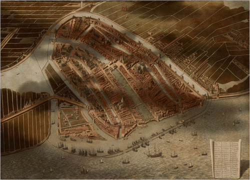
This urban motif evolved out of highly developed Dutch cartographic traditions. Large, intensively detailed maps included in the show suggest an almost obsessive preoccupation with geographical facts.
One of the strangest pieces is a painting of Amsterdam, seen as if from a hot-air balloon. Seemingly every building, street, canal and boat in town is carefully rendered, and shadows of clouds pass over the city and surrounding fields, creating an almost surrealistic mix of the real and the schematic. (Aerial views from Google Maps come to mind.) Made in 1652 or later by Jan Micker, it is a copy of a similar work from 1538 by Cornelis Anthonisz.
I confess, I liked the exhibit, but at the time I was not sufficiently attuned to the highly developed cartographic traditions of the Dutch. And anyway, the oblique angle on that bird’s eye-view map look more like Bing to me.
At the Height of Power for the Netherlands, the City in Glorious Detail [nyt]