What I Looked At In 1995: Vermeer’s View Of Delft

vermeer_view_of_delft.jpg
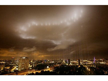
The inconvenient intrusion of war and political upheaval [i.e., the collapse of the Dutch government and the looming withdrawal of Dutch troops from their frontline deployment in Afghanistan] into my Dutch Landscapes project has sent me trying to re-find some discussion of Vermeer that’s stuck with me for years.
Like so many hundreds of thousands of others, I made a trip to the National Gallery in Washington in the winter of 1995 to see the first Vermeer exhibition in almost 300 years. It was a DC that may be hard for folks today to even conceive of: the show was abruptly opening and closing, thanks to massive snowfall and two government shutdowns orchestrated by an obstructionist Republican agenda led by Newt Gingrich. [I know, right? He seems so nice.]
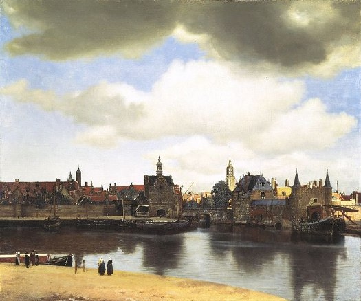
Anyway, 21 of the world’s 35 Vermeers were there, including View of Delft, loaned by the exhibitions only other venue, the Royal Gallery at the Mauritshuis in The Hague.
The Essential Vermeer puts the date depicted in the painting as early May, 1660 [the evidence: leaves on the trees, the boat activity, and the empty tower on the Nieuwe Kerk, because the bells were in the shop]. It seems so banal, so placid, so idyllic.
But I remember reading a discussion of how deceptive, or at least complicated, this peace was, in light of Delft’s own history. The argument centered on the high-contrast beam of sunlight Vermeer punched through his rainclouds to illuminate the Nieuwe Kerk, in the center background of the painting.
William of Orange had used Delft as a base for launching in 1568 what became the Eighty Years War, against Spain, the Hapsburgs, and the Holy Roman Empire, which turned on issues of religious intolerance, taxation without representation, and centralized power. William was assassinated in 1584, and because his family’s traditional seat, Breda, was still in Spanish hands, he was interred in the Nieuwe Kerk. So are his successors in the House of Orange-Nassau, who continued the fight, and who have ruled the Dutch Republic since it won its independence with the Treaty of Westphalia, which was signed on May 15, 1648.
But wait, there’s more! In 1660 the city was also still recovering and rebuilding after the Delft Thunderclap of 1654, a massive gunpowder explosion at a waterfront munitions warehouse that killed over 100 people–including one of Delft’s most well-known painters, Fabritius Carels–injured thousands more, and leveled a huge section of the city.
If Vermeer were alive in 2013, then, the equivalent painting might be the rainy skyline of lower New Amsterdam from the Hudson, where a ray of sunlight picks out the details of an unobstructed St Paul’s church–if George Washington and all the subsequent presidents were buried there. If there’s a Dutch equivalent of a bald eagle with a tear in its eye, Vermeer showed remarkable restraint by not including it.
UPDATE I’ll get out my DVD set in the morning to confirm, but I think Tyler Green’s right, it’s the first essay in Lawrence Weschler’s 2004 book, Vermeer in Bosnia, which was originally published as “Inventing Peace,” in The New Yorker, Nov. 20, 1995.
Yep, here we go, Weschler’s setup for the remarkable story of how the head of the International War Crimes Tribunal in The Hague kept himself sane by looking at the Vermeers at the Mauritshuis:

For, of course, when Vermeer was painting those images, which for us have become the very emblem of peacefulness and serenity, all Europe was Bosnia (or had only just been): awash in incredibly vicious wars of religious persecution and proto-nationalist formation.

Wow, maybe I should re-read the whole thing rather than post updates every page, but. Weschler quotes Harry Berger’s idea about Vermeer’s deployment of “‘conspicuous exclusion,’ of themes that are saturatingly present but only as a felt absence.”
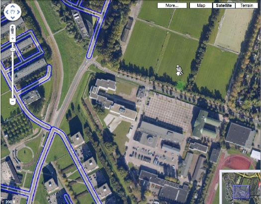
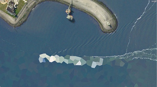
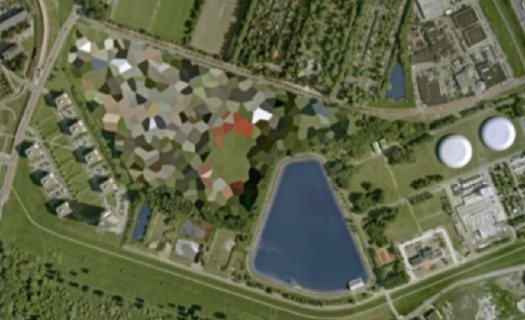
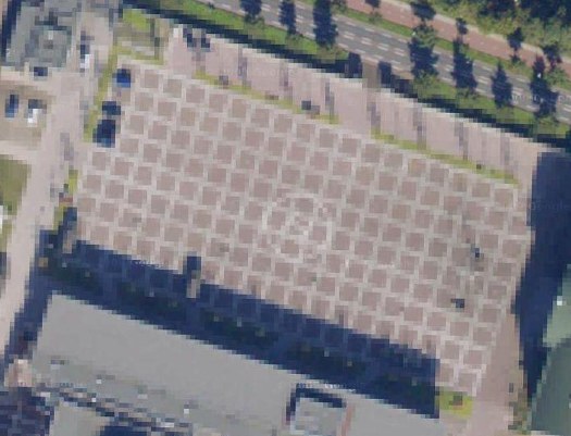
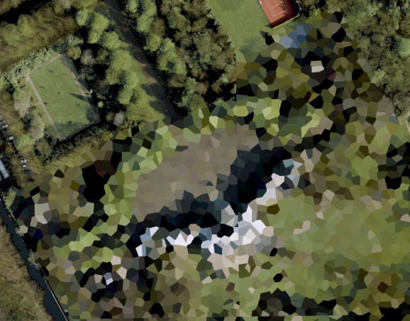
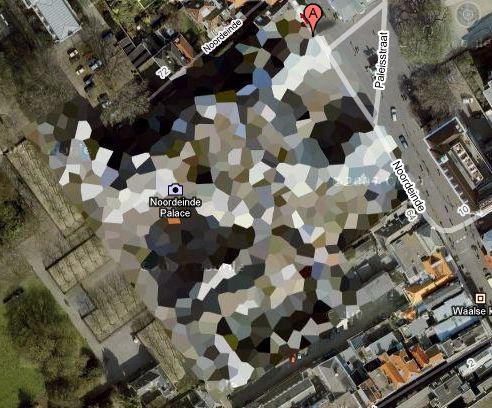
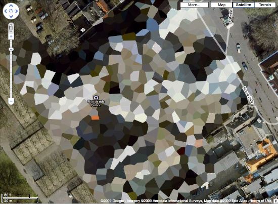
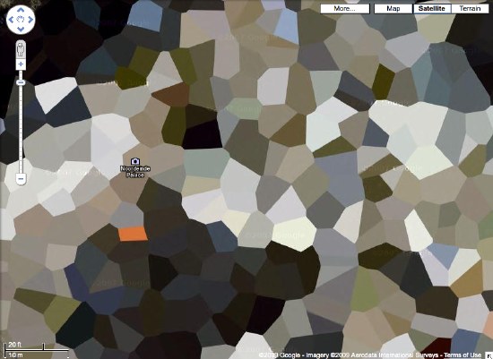
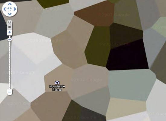
What a fantastic phrase, which immediately reminds me of a comment left by Jerome Bertrand on Ogle Earth’s original 2006 coverage of the Dutch Google Map censorship issue:

All the same, someone at Royalty level (AIVD?) would choose to typically blur out certain private residences – so it ends up you can find them quicker than others by just scanning for blurred spots in the area. This is helpfull [sp] when you need to know what’s hot.

Dutch Camo Landscapes On Google Streetview? Nee

no_google_streetview_rott.jpg
You may recall how Google Maps recently changed the polygonal camouflage on one of the Dutch landscapes I was using for my painting project.
I was back there, getting a clean shot of the nicely distorted grid plaza–the site belongs to the Koniklijke Marine, the Royal Navy, and is apparently the home address for the Royal Marine Band–when I saw that the Streetview icon was activated. Looks like Google’s camera cars reached the football field-filled outskirts of Rotterdam.
But not all of them. The available imagery shows that Google is excluding all street-level imagery from around the camo’d compound. The previous official explanation for camo-obscuring intelligence-sensitive sites was that the Dutch government claimed jurisdiction to censor aerial photography, but not satellite imagery. I guess there’s another law that forbids street-level photography from public roads, too? Yes and no.
A quick stop at the ur-Dutch Camo Landscape, the Noordeinde Paleis in The Hague, shows that Streetview is unavailable for its entire perimeter. But the other camo’d complex, a Royal Garage or something, to the northwest through the park, shows up just fine. The south perimeter of that giant, cut-n-past camo blob is just fine, which makes me think that the building being camo’d–I think it’s the HQ of the Defense Ministry itself–is on the next street up, which is, indeed, blocked. Unfortunately, Noordwijk ann Zee, the beachfront town that is the site of my favorite inexplicable, airdropped camo blob, has not yet been added to Streetview.
Update: In actual governmental/military news, the Dutch coalition government just collapsed in the face of growing opposition to extending the deployment of 2,000 Dutch troops in NATO’s operations in southern Afghanistan.

What I Looked At In 2000: Torben Giehler

torben_giehler_2001.jpg
As soon as I started thinking that Dutch Polygonal Camo on Google Maps would make great abstract landscape paintings, I thought of a some giant, abstract, polygonal landscape paintings I’d seen way back in 2000-2. But for the life of me, I couldn’t remember the artist’s name. From Julie Mehretu to Edvard Haberkost, to Benjamin Edwards to Kevin Appel to Carla Klein to Jules de Balincourt to Thomas Scheibitz, large-scale, geometrical/architectural/spatial/digital/landscape abstraction has not been in short supply. And of course, it was none of the above.
I’d seen one at “Collector’s Choice,” the exhibition I co-curated at Exit Art in the winter of 2000-1. It was on Norman Dubrow’s crazy, salon-style wall. Then the one that really haunted me was in a 2001 show at Caren Golden Gallery, curated, I think, by David Hunt. And then there was another show somewhere later, a solo show.
Well, thanks to, of all people, Mark Kostabi, I just realized it was NY/Berlin painter Torben Giehler. And the gallery was Leo Koenig, in 2002.
In her 2002 review of Giehler’s Koenig show, Roberta Smith described the artist as one of several interested in “formalist abstraction, digital cartography and photography.” She also guessed that making the paintings “must require hours of applying masking tape.” And sure enough, the many studio photos on Giehler’s website show piles of balled up blue tape, and also small printouts taped next to the canvas. It looks like he begins his work on a computer, and then enlarges and transposes the compositions by hand. [This 2004 Art in America review is excellent for describing the painting’s production, while adding absolutely nothing to their context or understanding.]
Some of Giehler’s landscapes are gridded; the earliest painting on his site is an explicit Mondrian flyover, a psychdelic reworking called Boogie Woogie. But his polygonal landscapes seem to form structures of their own. Like the mountain series he showed at Koenig. K2 is a favorite. [And a favorite of Giehler’s, too, apparently; he made a series of prints of it with Fawbush.] And Matterhorn has a very Dutch color scheme.
Glad to clear all that up.
above:
Tomorrow World, 2001, by Torben Giehler, exhibited in “Superimposition,” Caren Golden Gallery [torbengiehler.com]
Torben Giehler’s website [torbengiehler.com]

Dutch Camo Mashup Goodness

camo_crijnssen.jpg
I guess that’s the whole point of camo, you just never really know what you’re gonna see.
In February 1942, the Dutch minesweeper the HNLMS Abraham Crijnssen survived the Battle of the Java Sea, in which the Japanese Navy crushed Allied forces [AU, UK, NL, US] and invaded the Dutch East Indies [aka Indonesia].
To evade detection from the air and retreat to Australia, the Crijnssen‘s captain ordered the 186’ ship disguised as an island by covering it with branches.
Unlike the official, formal Razzle Dazzle camouflage technique used in WWI to confuse submarines, the Crijnssen‘s improvised approach worked. The ship survived and eventually ended up in the Dutch Navy Museum at Den Helder, the city at the tip of the North Holland peninsula which has long been a strategic nexus of Dutch naval and shipping operations.
crijnssen_gmap.jpg
In fact, when you look up the Crijnssen on Google Maps, there turns out to be a huge complex of Dutch Polygonal Camo just to the east, the main base for the Royal Dutch Navy.
dutch_camo_ship_helder.jpg
And the camo extends out into the water in order to cover a ship caught by Google’s Aerodata photographers just as it passed by the world’s most undeniably phallic breakwater. Wonder what the sailors’ nickname for that is.
Here a Google Map with both generations of Dutch naval camo, side by side:

View Larger Map
HNLMS Abraham Crijnssen at the Historical Naval Ships Assn [hnsa.org via boingboing]

The Everchanging Dutch Camo Landscape

Gather ye screengrabs while ye may, I guess.
The camo-obscuring of sensitive sites on Google Maps by the Dutch Intelligence Service (MVID) is a dynamic process. One of my favorite sites I found last November is a complex along the Maas in Rotterdam. The polygonal camo zone is surrounded by an equally artificial-looking geometric landscape:
rotterdam_camo_before.jpg
But when I pulled up that old post, the embedded Google Map showed a new, unobscured image:
rotterdam_camo_after.jpg
Thereby revealing the existence of a previously classified football field.
But wait, the image isn’t unobscured after all; it’s just obscured at a higher resolution. Oh no! It’s Dutch Camo 2.0!
rotterdam_camo_v20.jpg
My project just got overlaid with a thick, historicizing blanket of obsolescence. Which, for a bunch of Dutch landscape paintings, is probably just as well.
And I must say, I DO like what they’ve done to that helipad-equipped grid.
rotterdam_camo_v20_grid.jpg

Domes In Dutch Landscapes: Awesome Worlds Collide

schoonhoven_camo_gmap.jpg
I love it when several plans come together. Apparently, not all the Dutch Google Maps landscapes camo’d out by the Military Intelligence Department are actually sensitive sites. And some sites will toggle in and out of camouflage without warning or explanation.
One such site is the southern town of Schoonhoven, which has been poly’d off the map for most of the last four years, for no security reason at all.
schoonhoven_nato_ad.jpg
It’s no secret that NATO operated a SATCOM weather station on the north edge of town. The giant, geodesic dome that hid the doppler equipment is a prominent roadside landmark. But the base was decommissioned in 2005, just before Google’s contractor, AeroData, began its hi-res geoimaging flights over the Benelux region.
It was too late to get off the Defense Department’s polygon list, though, and so the entire town is obscured, even the Pegasus Steakhouse [above].
By 2008, with plans for the residential redevelopment of the abandoned base well under way, it was reported that townsfolk were finally being promised year-round, un-camouflaged Google Earth access to their homes. Maybe today was just a bad day.
06-2008: No More Blind Spot [ad.nl, image via ad.nl]
Urbex – NATO Schoonhoven photoset by Marc Duiker [flickr]

So They’re Surrealist Dutch Landscapes?

Been trying to think about where the idea of painting an intentionally obscuring, computer-generated, institutionally applied abstract pattern onto a systematically produced aerial photographic map of the entire world fits into the historical painting/photography, abstract/representational context.
From Andre Bazin’s 1945 essay, “The Ontology of the Photographic Image” [pdf]

…[P]hotography ranks high in the order of surrealist creativity because it produces an image that is a reality of nature, namely, an hallucination that is also a fact. The fact that surrealist painting combnes tricks of visual deception with meticulous attention to detail substantiates this.

What I Looked At Today [Until My Eyes Glazed Over] – Goethe

I don’t know who Bruce MacEvoy is, but his is the most exhaustive series of comparative analyses of various theories of color theory I’ve found. [aha. A web guy/artist who sold YHOO better than I did.]
As I debate in my mind whether to order paint colors for my Dutch Landscape paintings or to mix them myself, I find once again that painting, which I thought I knew something about, has deep historical, theoretical, and practical tranches which I’d never seriously considered.
Anyway, here’s a tiny bit of MacEvoy’s discussion of Zur Farberlehre (1810), the monumental, idiosyncratic, combative, and too-obscure treatise/polemic on color that consumed Johann Wolfgang von Goethe for nearly two decades:

goethe_color_magnet_handprint.jpgThis approach is exemplified in the watercolor Color Magnet (right), painted after a long evening discussion about the “polarity” of color with the poet Friedrich Schiller. The short vertical bars (far right) represent primordial yellow and blue refraction fringes (discussed below); the curved bars (at left), which are drawn to resemble the curve of iron filings across the opposing poles of two magnets, show the mixtures that result when “attracting” fringes are overlapped to produce the “union” mixture green (below) and the “deepening” extraspectral mixture purpur (above). These combinations produce Newton’s spectrum (horizontal bar, center bottom) and the extraspectral purples (horizontal bar, center top). Linking all mixtures together end to end, just as bar magnets can be linked at their opposite poles, produces the central vertical bar, the circumference of the hue circle, with the light emitting colors of sun and sky at the center. There is an almost mystical simplemindedness in this pursuit of patterns, resemblances and associations, but it is the essence of the Goethean approach to color.
Unfortunately, Goethe’s ambitious project has been rendered incoherent both by the deleted sections and by the English translation title: Farbenlehre simply means “chromatics,” with no “theory” implied (just as Sprachlehre means “grammar” and not “theory of speech”). Given Goethe’s sensitivity to language, it is not irrelevant to note that the root meaning of lehre is “lesson,” “teaching” or “learning from experience”. In the same way that a grammar of language simply describes the patterns in how we speak, Goethe wanted to develop a holistic “grammar” of color that describes how color behaves. He was looking for patterns in color experience — not for a theory of colors extracted from physical experiments. This makes his book an important precursor to German phenomenology. All these complexities have disappeared from the truncated English version of the book.

And then there’s this bit from further down, which seems to sidle up to the edge, to so speak, of these discrete polygons of algorithmic color I will paint:

Next, in what he motivates as a pedagogical move, Goethe illustrates the “primordial” shadowing or distorting of images with the colors produced by a prism. These illustrate what is probably the central analogy of his book: that color, to the extent it has an external, physical origin, results in the blending of edges or boundaries between dark and light; edges are both the essential element of an image and the primordial cause of color appearance:
“[When viewed through a prism], we have found all unbroken surfaces, large or small, to be colourless, yet at the outlines or boundaries [edges], where the surface is relieved upon a darker or lighter object, we observe a coloured appearance. Outline, as well as surface, is necessary to constitute a figure or circumscribed object. We therefore express the leading fact thus: circumscribed objects must be displaced by refraction in order to exhibit an appearance of colour.” (¶197-198)

Not that Goethe was at all correct, of course. [Or as MacEvoy puts it, “Even when charitably summarized, Goethe’s theory of color is incomplete, inconsistent and incomprehensible.”] But it’s still kind of fascinating.

Collecting Dutch Landscapes

I just got the first prints of Dutch Landscapes to paint. And I’ve captured a few more to prep for printing. Here are a few more of the camo-obscured Dutch sites I also like but haven’t gotten around to capturing and printing yet. Most are military or intelligence installations of some kind, culled from the Onherkbaar/Unrecognized list here:

View Larger Map
rotterdam_camo_before.jpg
The landscape and architecture around this one on the Maas in Rotterdam has a really nice, explicit geometry of its own. The light in some of these is just wonderful, too. So strong and clear. Which is what you’d want, obviously, for aerial photomapping. As Stefan reported on Ogle Earth back in 2006 when this dataset debuted, the fact that these were not satellite images is intrinsic to their camo censorship. Satellite imaging is considered to be beyond Dutch jurisdiction, but permits are required for aerial surveying, and the images are reviewed to censor “vital” military or intelligence buildings and sites.

View Larger Map
More landscape geometry. This one reminds me of Isamu Noguchi’s admiration of hatake, the rice paddy landscape of Japan, a terrain which, like the Netherlands, was the product of centuries of intensive human sculpting and engineering. [That said, I can’t find any mention of the Noguchi quote I’m thinking of.]

View Larger Map
huistenbosch_gmap_camo.jpg
This one’s the Palace Huis ten Bosch, the Queen’s residence. I love that the tennis court and the sculpture garden at the top are not considered “vital” sites. While trying to identify any of the installed works, I learned that H.M. Queen Beatrix is quite a fan and practitioner of sculpture and maintains at studio there at the palace.

Houses Of Orange

dutch_palace_gmap4.jpg

NL Architects
thinks it might make a good Herzog & deMeuron project, but I think Google Maps’ security pixelization of the Dutch Royal House’s Noordeinde Palace in Den Haag would make an absolutely fantastic series of landscape paintings.
dutch_palace_gmap3.jpg
dutch_palace_gmap2.jpg
dutch_palace_gmap1.jpg
Where else in the world are such things? The DRH’s summer palace at Huis ten Bosch; an AZF chemical weapons factory in Toulouse
There’s a surely incomplete list of obscured satellite images on Wikipedia, and a map. Which includes Mastercard’s corporate headquarters in Westchester, which actually looks like it was painted over. They call it “watercolored.” Perfect.
here’s the list of camo’d Dutch sites I’ve been working with.
Previously:
architecture for the aerial view, including WWII factory roof camouflage: the roof as nth facade
art for the aerial view: Calder on the roof

More On The Bosbaan Tribune Building, Gesloopt in 2003-4

bosbaan-before-building.jpg
Here’s a picture of what turns out to be the finishing tower at the Bosbaan in Amsterdamse Bos. It was demolished when the Bosbaan was widened to meet international rowing competition requirements. I can’t tell, though, if this was the same as the “tribune building” “from the twenties” [??] that Korteknie Stuhlmacher Architects mention was also demolished in order that they could build a new boathouse for Okeanos, the student rowing association, and RKNB, the Royal Dutch Rowing Association.
There’s also a new finish tower, but it’s not really a tower, just a box.
bosbaan_boxes-ks.jpg
Roeigebouw Amstelveen, 2000, 2005 | Korteknie Stuhlmacher Architecten [kortekniestuhlmacher.nl]

Foreman’s House At The Bosbaan (gesloopt)

The Bosbaan, or Woods Course, is the oldest manmade rowing lake in the world. It was built in the Amsterdamse Bos in 1936, and it was expanded in 1954.
Which gives a couple of interesting date possibilities for this awesome opzichtershuisje, or foreman’s house. The simple, clapboard and wood frame construction makes me think it’s the latter, though, a post-war modernist bonus. Here’s a Google Map view of it.
Do you see that floating staircase on the front corner there? Do you wonder if Winy Maas saw it at some point, too?
Unfortunately, “gesloopt” is Dutch for “demolished.”

Wow. “The Selling Of The War” on VPRO

A couple of months ago, I was contacted by producers from Backlight, an investigative documentary TV series on the Dutch public broadcaster VPRO. They were trying to locate and interview Scott Sforza for a program set for the 5th anniversary of the invasion of Iraq. [I’d tried and failed to contact Sforza for my Cabinet Magazine article about his work last summer.]
The episode aired the other night, and it’s online now, and well worth the watch, even if you don’t speak Dutch; most of the talking heads–including me–speak English.
It’s amazing on many levels, not the least of which is the sheer impossibility of an in-depth, retrospective investigation called “The Selling Of The War” ever airing on an American news network. VPRO focused in on a couple of very specific elements of stagecraft, manipulation, and deceit from 2003: Colin Powell’s UN speech; the White House-built stage at the CENTCOM media center in Doha, Qatar; and the Coalition press conference where Gen. Tommy Franks announced the invasion, which had a controversial–and damning–Dutch hook.
vpro_doha_jan_blom.jpeg
I did my Sforza fanboi spiel about human wallpaper, and it turns out that among the human wallpapers Franks pulled on stage and introduced as a Coalition partner was a Dutch colonel, Jan Blom [on the far right above]. But the Netherlands were not part of the Coalition. The guy was a NATO public affairs officer, who was grabbed at the last minute to provide balance and camo variety to the backdrop. Naturally, word of the scandal that erupted in Holland after Blom’s appearance has not yet penetrated the American heartland.
The two guys in the middle were Franks’ equals from the US’ actual Coalition partners, Great Britain and Australia, who were only told at the last minute by a White House operative that they would not be participating in the press conference. The guy on the far left was another prop, a Public Affairs guy from Denmark. So the stagecraft managed to simultaneously insult and dissemble. That’s Rumsfeld’s new lean&mean Army!
Perhaps it’s really a minor point, but it’s just one of many that show how deceptive and manipulative the administration was in the crucial period of the run-up and the invasion. Again, try to imagine a US network news show of any kind devoting 30 minutes to pull apart such a lie. [Actually, it’s probably half that time; there was a great deal of time devoted to former Powell Chief of Staff Lawrence Wilkerson’s explanation of how the UN WMD speech came together, something that has been covered in the US.]
So anyway, happy anniversary!
Program page: Tegenlicht: De Verkoop van een Oorlog [vpro.nl]
Watch the episode online via real player [vpro]

Joep van Lieshout: Those Who Can’t Do, Make Art

Now I’ve been a fan of Joep van Lieshout’s work for a long time, even if a lot of it’s too irreverent or too bombastically oversexualized to evangelize about regularly. [“You see, mom, he builds these room-sized uteruses with built-in bars…”]
But listening to his talk at Tate Modern last fall, it wasn’t his successes so much as his failures that stuck in my mind. The arc of the interview with curator Marcus Verhagen was the failure of AVL-Ville, Atelier Van Lieshout’s attempt to turn its Rotterdam waterfront studio complex into an independent, anarchic state, and how that flirtation with utopianism eventually led to the artist’s current dystopian fascination. The artist then explained his concept for a hyper-capitalist, sustainable, totalitarian slave city with a population of 200,000 that produces EUR7 billion in profits each year. So far so good [sic].
When it got to the Q&A, though, someone asked van Lieshout if his zero-impact utopia, with its organic urban farming, &c., was so great, why not keep developing it? He dismissed the idea, since it would involve actually running the thing, then it’d take expertise, and attention, and involvement with the bureaucracy, and anyway, who knows if it really works? [Obviously, I’m paraphrasing here.]
The gist of his reply, though, was reality’s too hard, so he’s leaving it as art.
Then when someone lobbed a generous softball of a question by describing his structures and installations as “cinematic,” van Lieshout punted again. Though he, too, conceives of his work as the sets upon which some unspecified drama unfolds, he never makes films, because he “doesn’t know how.”
I’d always thought of AVL-Ville as something of a conceit, but I had no idea how utterly dependent it was on the benign neglect of Dutch bureaucrats, and I certainly didn’t know how quickly and utterly it folded when faced with the most rudimentary challenge. And similarly, when even a clueless yahoo like me can figure out how to make a movie, expertise and technology just are not credible obstacles anymore.
Sure, art is not, by definition, the real world, but I’d always somehow considered it to be superior in its distinctiveness. And yet here was van Lieshout’s art being defined by its impractical, unproved inferiority in one case, and as the refuge for ignorance in another. We unconsciously give Art a presumption of cultural significance that, what do you know, it may not automatically deserve.
Too often, it gets considered only on its own terms, in a bubble, a world [sic] apart from the real world. It’s why the mediocrity of an artist like Mariko Mori gets taken seriously when it’s dwarfed technically and philosophically by CG and narratives of the best films and video games. Or why a piddly little spiral jetty is raised to masterpiece status while the US Army’s vast earthworks at the nearby Dugway Proving Grounds are ignored and detested. There’ll be a reckoning some day, a reality check, and a lot of art that was considered intrinsically valuable or important will end up as worthless oddities, like 19th century jewelry made from that most rare of metals at the time, aluminum.
Talking Art | Joep van Lieshout [tate.org.uk via imomus]

Bombardment Periphery, Rotterdam

mothership_brandgrens.jpg

As part of Rotterdam 2007 – City of Architecture, the city commemorated the 15-minute-long German bombing on May 14, 1940 that destroyed the city center, precipitated the Dutch surrender in WWII–and ultimately provided the occasion for all that new architecture. The area destroyed by the bombs and the ensuing firestorm is demarcated by the Brandgrens, or Fire Limits:

The Fire Limits
14.05.2007
On Monday 14 May, in the evening, Rotterdam 2007 City of Architecture will illuminate the fire limits of Rotterdam’s city centre with over one hundred light beams.
The fire limits mark the areas of the city that were destroyed by the bombing on 14 May 1940 and the ensuing fires that broke out. From 10.45 pm a blaze of light beams on these boundaries will light up the skies, making the true impact of this devastating event visible throughout the entire city.
The bombing ‘only’ lasted fifteen minutes but managed to destroy practically all of Rotterdam’s city centre. Even before the war ended, it was decided not to replicate pre-war Rotterdam when reconstruction began, but to turn the city into a modern, revitalised city. The fire limits highlight the differences between the old and the new in many places in the city centre, which although visible, have never been experienced as a whole before. On 14 May 2007, the art producer Mothership will illuminate the entire fire limits, stretching almost 12 kilometres, turning this historic event into a sight that everyone can see.

Such a prominent spatial use of spotlights as a memorial these days obviously evokes references to the Towers of Light memorial. Like the World Trade Center version, this project, produced by the art collective Mothership, is intended as a temporary, ephemeral precursor to a permanent memorial demarcating the Brandgrens. But that’s actually not the most interesting part of this project for me.

firelimits_mothership.jpg

Though the memorial’s official path through the city was only recognized in February, the idea of the Brandgrens has been as integral to the post-war identity of Rotterdam. The Fire Limits [or as Mothership translates with a bit more thesaurian flair, Bombardment Periphery; Babelfish translates Brandgrens as “Fire Boundaries”] is a commemoration of a Nazi attack that uses the Nazis’ own vocabulary of spectacle, specifically Albert Speer‘s 1934 Lichtdom, the Cathedral of Light, at Nuremburg. The rendering [above] reads almost like a direct quote of Lichtdom, in fact.

Lichtdom.jpg

As it turned out, Bombardment Periphery looked uncannily like a re-creation of a nighttime bombing, with evocations of anti-aircraft searchlights, groundlevel glow, and illuminated cloud cover. I’d be very interested to hear what the reaction was to this event [the commemorating, that is, not the attack.]

brandgrens_2.jpg

It’s a bit absurd, but the first image that comes up in my search for night-time air raid photos was from Los Angeles.

La_air_raid.gif

In the early morning of February 25, 1942, unidentified flying objects were spotted over Los Angeles, triggering a massive anti-aircraft barrage that killed three civilians [three more died of heart attacks] and sparked a flood of bitter criticism and controversy. No definitive explanation has ever been made of the objects. The incident was inspiration for Steven Spielberg’s comedy [sic], 1941.
The caption for this photo, which ran on the front page of the LA Times, is incredible:

Scores of searchlights built a wigwam of light beams over Los Angeles early yesterday morning during the alarm. This picture was taken during blackout; shows nine beams converging on an object in sky in Culver City area. The blobs of light which show at apex of beam angles were made by anti-aircraft shells.

The obvious question, of course: Is next February 25th too soon for someone to recreate a wigwam of light beams over Culver City?
Bombardment Periphery Gallery [enterthemothership.com]
Rotterdam2007: The Fire Limits [rotterdam2007.nl]
West Coast Air Raid [wikipedia]